by Paul R. Spitzzeri
As part of a major planning effort to remake the fifteen-year old City of Industry, Gruen Associates, a well-known Los Angeles planning and architectural firm, followed up its creation of a General Plan for the city in 1971 with a specific application of principles from that plan for a “Civic-Recreational-Industrial Project No. 1” in a report from that July.

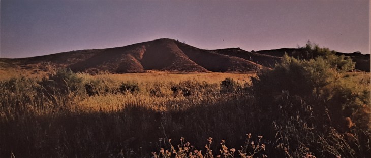
The area covered was from about Seventh Avenue to the west to Nogales Avenue on the east and one of the major sections within the project area was Puente (or simply “P”) Hill, which had been used for decades as a landfill for the general La Puente Valley. The project within a project was labeled a “Civic-Recreational-Conservation Area” and the report sated that this element
fulfills City and [Urban Development] Agency goals by providing joint capital improvement facilities complementary to industry, by conserving natural resources and by crearing a setting that is beneficial to neighboring communities.
The 500-acre parcel was slated to have a 27-hole championship golf course designed by the internationally-known firm of William P. Bell and Son and the location came about by looking at which portion of the hill “presently excel in natural beauty” and also comprised “areas scarred through past sanitary disposal operations.” Having a dramatic elevation above the valley with stunning views was also highlighted and improvements such as ponds and small lakes within fairways and greens facilitated the storage of irrigated water, as well as served to beautify the area and provide “a strategically located golf hazard.”

Another notable component of the course was that the final green in the two nine-hole legs were to be at the bottom of a plateau, so that
golfers will travel from these greens to the clubhouse via a low-speed funicular, similar to an inclined elevator, which is designed to offer a pleasing and unique experience to the golfer.
While the course was to take in much of the eastern section of the property and the majority of the acreage, there was a “parks and conservation” portion at the northwest corner of the hill that would “use escaped scarring during the previous sanitary cut-and-fill operation.” Because it had amply trees and was “characterized by long, gently valleys which rise to a picturesque backdrop of steep hills,” this was ideally suited for what was termed a “wilderness area.”

The report went on to suggest that improvements would include “sports fields (baseball, football, etc.); tennis courts and swimming facilities . . .; facilities for YWCA and YMCA [use] . . .; [and] several picnic areas capable of accommodating large and small groups . . . located in areas excelling in natural beauty.”
Those steeper areas were intended to be “set aside as wilderness areas for nature study and conservation programs.” An equestrian center with bridle trails and “park play areas for younger children” were also called for. There were section of steep hills next to the park sections and surrounded by the golf course that were “set aside as a conservation area; hiking and equestrian trails may extend into this portion” as well as on the perimeter of the site.
There were several parcels yet to be obtained to complete the plans outlined, as well as a “Development Opportunity Area” between the park area and golf course, the use of which “will be determined by future City and area needs,” though “an interim use related to the park and recreation program” was mentioned. The idea was to keep this liimited in terms of improvements “to maintain flexibility in respect to the ultimate disposition of the area.”
Finally, there was a proposed “Industrial Exhibit-Conference Center” next to the golf course with a “Junior Achievement Center,” that was undefined as to its proposed function, while the former was slated to showcase and highlight industrial activities to attract development and businesses.

The thought was that the course and the center would be complementary and building them together “will result in construction cost efficiencies, a high level of service and a wide offering of activities.” They would have separate entries and “identity”, but share a kitchen, offices, heating and cooling plants, parking and other elements.
What was finally built by the early to mid 1980s was somewhat different, as is often the case with broad plans like this. The exhibit and conference center wound up being a Sheraton hotel and conference facility. The “parks and conservation” segment had an equestrian and exposition center, now called the Expo Center, but other portions like the picnic area, play area, sports fields and others were not included. As to the golf course, it was completed, with the funicular included, and the views and layout are remarkable.

The report included several photographs showing the hill in its current state, as well as a number of models to show what it would look like when developed as called for. It is very interesting to look at those photos of how the area appeared nearly a half-century ago and then drive around the area today to see the transformation.
Next week, we’ll take a look at what was called “The Historic-Cultural Element” including plans for the Rowland House property and what became the Homestead Museum.